
Project Goes Beyond Repaving Parking Lots
Better routing of pedestrians and bicycles near the Como Lakeside Pavilion is among initial ideas on the table when Parks and Recreation rebuilds parking lots near the Pavilion and golf course next year.
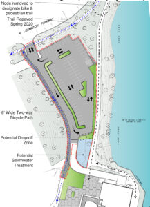
One idea separates cyclists and pedestrians. This separation would occur in the stretch from where paths now converge south of the Pavilion (near Schiffman Fountain) and north of the Pavilion (near Como Lake Drive and Lexington Parkway).
Existing paths closest to the lake would be for pedestrians only. Cyclists passing through would ride on the newly repaved, two-way path along Lexington. Cyclists visiting the Pavilion would take a new, two-way path that would be built along the west side of the Pavilion’s south parking lot and the south side of the Pavilion’s north parking lot.
[Separating cyclists and pedestrians is one of the recommendations from the Como Community Council’s Pathways Project. You can read a short version of the project report and its recommendations by opening the PDF from the right column. Or, see a more visually pleasing presentation by downloading a slide show printout, also from the right column.]
Beyond the fundamentals
Project manager Anne Gardner and her Parks and Recreation colleague, Cheeneng Yang, unveiled initial concepts for parking lot reconstruction during District 10’s Land Use Committee meeting July 1. The existing lots, which date back to 1993, are heavily utilized but in very poor condition, they said. The reconstruction would keep 158 parking spaces at the golf course, increase spaces from 144 to 151 in the south Pavilion lot, and reduce spaces from 77 to 65 in the north Pavilion lot.
While rebuilding the lots, Yang and Gardner told the committee, they hope to do more than bring design, stormwater management, and traffic flow up to modern standards. On the Pavilion side, for example, they’d like to make the lots and entrances “more inviting and welcoming, to complement the grand building that’s there,” Yang said.
Their initial concept also looks at making better use of the open lawn between the Pavilion and Hamm Waterfall, and creating a boat launch south of the Pavilion. How much they can accomplish will depend on how far funding goes; the $1.6 million project is being paid for by the state’s Legacy Amendment.
Plans will be refined
Yang stressed that their initial proposals are “very high-level concepts” that will be refined. [You can view the concepts for each lot in the PDFs in the right column.]
Yang and Gardner told the committee a lot of work remains. Their to-do list includes additional engineering; consultation with Capitol Region Watershed District and Lancer Catering (which manages the Pavilion); design of signs, kiosks, and other potential tools to improve wayfinding and the “sense of arrival” that visitors experience; and such details as where to relocate charging stations for electric vehicles, screening trash containers outside the Pavilion, and finding a better location for the existing flag pole.
Yang and Gardner hope to have final plans in place by the end of 2020, put the project out for bid in spring 2021, and complete construction by early fall 2021.
If you want to comment
Parks and Recreation now has an interactive map that community members can use to enter comments and suggestions. (In the right column, you can also read a summary of comments from neighborhood residents that the Como Community Council collected in summer 2020.) A few tips on using the map:
- An “About this project” box pops up when you open the map. To close the box, click the X when you are done reading.
- The project is broken into three sections – one for each parking lot. Each lot is highlighted on the map; you can move the map around to get to the lot you want to examine.
- When you click on a lot, the map zooms into that section and opens a box in the right column. The box gives a summary of that section of the project.
- Also in the summary box: a link that will download a PDF with more-detailed sketches of each section of the project. The PDF contains sketches of all three lots, so you have to download it only once.
- To close the summary box, click on the left-pointing arrow at the top of the box. Doing that replaces the summary box with icons to indicate four kinds of feedback: “This works well,” “General feedback,” “I have an idea,” and “I have a concern.”
- Click on an icon, then click the “Submit a Comment” link that pops up. This opens text fields in which you can write your feedback; you can also click a specific location on the map to highlight exactly what you are talking about. All the icons work the same; to move to a different icon, click on the left-pointing arrow at the top of the box.
Originally published July 17, 2020; last updated Sept. 10.
Copyright 2020 Como Community Council. This work is licensed under a Creative Commons Attribution-NonCommercial 4.0 International License